
 My first night in Colorado is spent in Pueblo City at a totally unmemorable Super-8 motel where few of the amenities - e.g. soft drink dispensing machine, laundry powder dispenser, my room’s credit-card-type plastic key fob! .. etceteras - actually work. The following day, Mon-Aug-13, I hit the road by around 10:30am and continue my westward journey along US-50.
 Soon the terrain takes-on more relief and I get my first glimpses of the Rocky Mountains on the far horizon.
 Yesterday I passed through yet another time zone; I'm now in 'Mountain Time', which is 7 hours behind the UK
 After around 120 miles (193 km), and 2½ hours' of riding, I climb up and across the southern end of the Sawatch Mountain Range through Monarch Pass - Elevation 11,312 feet (3,448m). This is the highest elevation I've been so far, by quite a margin. But who knows, I may go even higher in a week or two; this will depend on timing and the then prevailing weather.
The Pass is located on the Continental Divide, meaning that all water falling west of here will probably end up in the Pacific; any falling to the east will eventually make its way into the Atlantic Ocean, most likely via the Mississippi River.
225 miles (362 km) later and I check into my next motel in Montrose.
Tuesday, August-14
 Today’s ride will only be around 135 mile (217 km), south along US-550; a stretch of road otherwise known as the 'Million Dollar Highway'. I leave Montrose by late morning, as I have plenty of time on my hands.
  Although the entire 75-mile (121-km) stretch south to the township of Durango is referred to the 'Million Dollar Highway'...
 .. it is really only the first twelve miles south of Ouray Township, through the Uncompahgre Gorge, to the summit of Red Mountain Pass which gains the highway its name.
  The road through the gorge is characterized by steep cliffs ... and the complete lack of guardrails.
Gulp!
Did I ever mention that I really can't stand heights?
 The ascent of Red Mountain Pass is characterized by the number of hairpin "S" bends ('Switchbacks' in motorcycle speak) used to gain elevation.
The origin of the name ‘Million Dollar Highway’ is disputed. Some claim that it originated from "it cost a million dollars a mile" to build back in the 1920s; others maintain - because this is gold-mining country - that the road contains "a million dollars" in gold ore within the road's hardcore dirt foundation
 I am forced to stop at some road works for 30 minutes. I shut down the STeed and wander to the front of the queue of waiting vehicles and strike up a conversation with a couple of Harley riders, accompanied by a BMW R1150 GS Adv rider, who are all travelling back to their home state of Mississippi
 'Tas' (an abbreviated name for his nickname 'Tasmanian Devil') proudly boasts to me that they are all members of 'The Biker Church' and soon starts quoting some biblical Psalms to me.
Tas explained that he too was involved in a nasty motorcycling accident back in September last year ['06]. We compare our respective surgical scars. Tas, however, was left for dead by the accident's perpetrator at the scene of the incident. Besides the now mended clavicle and ribs, he has three metal plates inserted in his LH wrist. Moreover, he was up and riding within a month of the accident.
This put my little 'misfortune' that occurred back on March-17 into perspective!
Tas then hands me a strip of beef jerky, something I've never eaten before, and encourages me to chew it until the leathery-like substance turns soft, then 'swaller' it, or spit the remains out ...
 .. "okay, okay, don't look at me like that .. I'm gonna eat it, okay"
T'was actually pretty good too! - a few strips of this stuff and a bottle of water, could easily get you through the day until dinner time. I guess this is how trail-driving cowboys survived all those years ago.
The Mississippi Riders encourage me - cuz I'm so close - to go take a look at the Mesa Verde National Park. Methink .. .. 'and why not?'
 But soon it's onwards, as I stop from time-to-time to take-in some great views ...
 .. and upwards ...
 .. through stunning alpine-type scenery.
Here's the view from the top of the Molas Pass - Elevation 10,899 feet (3,322 m).
By late afternoon I arrive at Durango; grab a meal of very tasty Texas-style barbequed ribs; before moving on west another 28 miles (45 km) along Hwy-160 to the smaller township of Mancos, where I settle for the night.
It's been another good day.
Wednesday, August-15
 So my immediate plans are hastily altered to include Mesa Verde NP. I also want to get my picture taken at the close-by 'Four Corners Monument', which is the intersection of the four states of: Colorado - New Mexico - Arizona - and Utah. FYI - This is the only point in the United States where four states touch each other.
Shortly after breakfast, therefore, I make my way south-westwards further along US-160 to the Monument across the high desert plateau region that surrounds this particular landmark.

 Just before noon I arrive at Four Corners and get a volunteer fellow sightseeing tourist to take my picture where the four state borders meet; then have a chat to a Christchurch-based Kiwi biker who's over here for two months just riding around the western US states and Canadian provinces on his shipped-over dual-purpose (enduro-offroad / road-tourer) machine. We have plenty in common to talk about, of course.
I vow to myself that I will return to these 'Four Corners' early next year ['08] .. but that'll be another story.
I then ride around encircling the Monument - as ya do - thus crossing through four states within 20 seconds, then skidaddle back up US-160 towards Mesa Verde.
 Mesa Verde* National Park rises high above the surrounding country.
 National Geographic Traveller picked Mesa Verde NP as one of "the 50 Must See Places of a Lifetime"
*Mesa Verde is Spanish for "green table"
 For 750 years, the Ancestral Puebloans occupied the area within the park from the 500s to the 1200s.
The vistas, as you can see, are spectacular.
 Here's 'Navajo Canyon'
 You just can’t help but notice that the trees and brush hereabouts are dead, charred with what appears to be widespread fire damage. So later I did some research into the mystery.
Since the 1920s there have been, on average, 8 fires per year. Since 1970 this average has increased to 20-25 fires per year.
The last three BIG burns occurred in:
2000 - 19,709 acres ..
2000 - 1,352 acres ..
2002 - 2,601 acres ..
.. were set alight. All resulting from lightening strikes. The main casualties being the prevalent Pinyon and Juniper trees.
 Cliff Canyon where ...
 .. looking east, from the Canyon's western overlook, across to the 'Cliff Palace'. This is an impressive ruin built into an alcove in the Canyon’s eastern sandstone cliff. There are about 150 rooms in the structure where it is estimated that between 100 and 120 ancient people once lived.
 But it's now mid-late afternoon (around 3:45pm) and I still have just under 200 miles (322 km) to go before I reach tonight's stopover destination of the Gateway Canyons Hotel & Resort. Better get going then!
 But my preferred, more direct and therefore quicker, route along the scenic SR-141 is shrouded by storm clouds that are spitting thunder and lightening. I just don’t fancy going there! So I decide to head all the way back up the 'Million Dollar Highway', through Montrose again - but this time from the opposite direction - and further along US-50 almost to the City of Grand Junction, where I pick-up SR-141; then travel southwest through canyon territory in the semi-darkness of dusk.
I see my first black bear along the final last few miles of 141. There it was in the middle of the road, gaping at me curiously. I gaped back! Gawd, I really wish my camera was handy and there was more daylight around. But within seconds the beast scarpered off into the brush. Bugger!
 The unplanned excursion back up to Montrose and getting to my destination 'the long way round' added approximately a further 150 miles (241 km) to my day's expectation. I arrive at the Hotel after 445 miles (716 km) and 11 hours in the saddle, in the dark, completely knackered. I shall sleep well tonight, that's for sure.
... ZZzzzzzzzzzzzzzzzzzzzzzz
Thursday, August-16
 I'm up early to catch the morning's first rays. The glow on the very nearby 'Palisade' is spectacular.
 The Gateway Canyons Hotel & Resort is like no other place that I've ever stayed at before. A 'touch of class' literally in the middle of no-where. I feel spoilt .. just for a change from my usual utilitarian motel stopovers.
I was put onto this place by a fellow Canadian STer, Alberta-based Tim Graham. Tim has recently been magnificent in providing me with all sorts of valuable information and helpful suggestions for my future routing up to his home city of Calgary. I hope to meet and greet Tim, and his wife Diana, in around 10 days' time in South Dakota.
 By mid-morning it's again time to move-on ...
  .. and back up SR-141 towards Grand Junction.
  It's a magnificent day, and place, to be riding a ST1300 Pan-European motorcycle.
 But I divert just before reaching the City and scoot eastwards along I-70.
This shot was snapped on I-70 at the acceptable speed limit of 75 mph (121 km/h)
 Just 12 miles (19 km) later and I turn off onto SR-65 towards the summit of the 'Grand Mesa'
 The views from the northern side of Grand Mesa are breath-taking. I can see for what must be nearly 100 miles
 .. over the lakeland summit ...
 .. to the southern side, where I can again fool myself into thinking that I can see the states of Arizona and/or New Mexico on the far horizon.
I end the day back on US-50 where I complete today's 180-mile (290 km) run in a Grand Junction City motel.
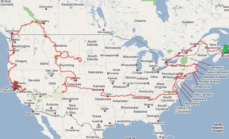
 The route(s) from the Kansas border, through Colorado, so far
Friday, August-17
 I've been on the road now, with hardly a sustained break from travelling for around two weeks. It's time for a rest.
So I pick a township from the many on the region's map, that lie broadly within my intended journey. I decide upon Meeker, elevation 6421 ft (1957 m). It should be cooler up at that height .. In hunting territory.
By early afternoon I've checked in, for three nights, at the Meeker Hotel on sleepy Main Street.
 Supposedly haunted, this establishment has been open for business since 1896 ...
 .. so it's about time then .. for it now to be haunted by a Cornishman! .. ;o)
 My Colorado routing at closer inspection.


